The $7 billion voter-approved plan to grow public transit in Austin includes tunneling two light-rail lines through the core of downtown to move people faster than the speed of traffic through the densest part of the city.
This week, transit planners offered the most detailed vision yet of how the Orange and Blue Lines could take shape underground. The plans are only 15% done, so a lot could still change. The public will have a chance to weigh in this summer.
Station Locations
The Blue Line, which starts at Austin-Bergstrom International Airport, would cross a bridge over Lady Bird Lake and go underground before arriving at a station on Rainey Street just south of Cesar Chavez Street.

Austin Transit Partnership
The Rainey Street/Mexican American Cultural Center Station could provide easy access to the Ann and Roy Butler Hike and Bike Trail and the Waterloo Greenway, a 1.5 mile park planned from 15th Street to Lady Bird Lake.

Austin Transit Partnership
The Blue Line would continue north and arrive at an above ground station near the Austin Convention Center/Brush Square Park. This location would connect with the Red Line commuter rail and a future Green Line planned to go to Colony Park and eventually Elgin.

Austin Transit Partnership
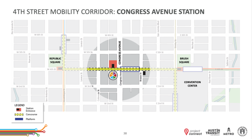
From the Austin Convention Center, the Blue Line would turn west down Fourth Street with the next stop at Congress Avenue.
Austin Transit Partnership
One early concept for the Congress Avenue Station imagines a multi-story building that includes amenities like a public market with retail and office space.

Austin Transit Partnership
As the Blue Line continues west, it would stop next at Republic Square Park and meet up with the Orange Line. Republic Square is already a major hub for Capital Metro buses.

Austin Transit Partnership
Capital Metro asked the state legislature for permission to build directly under Republic Square and Brush Square parks. A bill passed the House but never made it to a vote by the full Senate. That forced a change of plans by Austin Transit Partnership, a local government corporation set up by Capital Metro and the city of Austin to implement Project Connect. So the reimagined Republic Square Station would not touch the park at all; it would be located on an adjacent sidewalk extension.
ATP planners are speaking to the companies behind two developments under construction between Fifth and Sixth streets to see if they could incorporate additional station entrances near Republic Square.
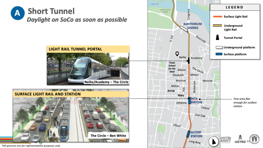
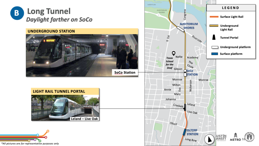
The Orange Line, which would start at Stassney Lane and could eventually extend south to Southpark Meadows, would enter a tunnel either before or after the South Congress Avenue Station. Both options are being considered.
Austin Transit Partnership
Austin Transit Partnership
The Orange Line would head from the South Congress Station north to arrive underground at Auditorium Shores. Initial plans called for the Auditorium Shores Station to be above ground, but factors including utility placements and flooding concerns convinced engineers the tunnel entrance should be further south.

Austin Transit Partnership
From there, the Orange Line would go under Lady Bird Lake. The tunnel would be dug just west of the First Street Bridge and head toward the Republic Square Station to meet up with the Blue Line and establish one of the most important transit hubs in Central Texas.
The Orange Line would then continue north to an underground station located just west of the Texas State Capitol. Original plans called for two stations in this area, but they've been combined into one. Three station placement options are under consideration with two possible "tunnel portal" locations where the train would emerge from underground.

Austin Transit Partnership
Station Design
Project Connect planners are looking around the world for inspiration on station designs, including in the Dutch city of Delft and Sydney, Australia.

Austin Transit Partnership

Austin Transit Partnership
"One of the benefits of creating a light rail system from scratch, essentially, is that we're not jerry rigging any kind of legacy system," ATP Chief of Architecture and Urban Design Peter Mullan said. "We can look to the best examples globally and then build them here in Austin."
Features ATP is looking to include in underground light-rail stations include:
- Escalators
- Natural light
- Sight lines from multiple levels down to the platform
- Clear wayfinding
- High ceilings
- Platform screen doors to prevent people from falling on the tracks
All downtown stations, except for the one west of the Texas Capitol, would be linked by a walkable underground concourse that could include shopping.
A cross-section of Fourth Street shows how planners want to make the corridor a three-level system. Underneath street level, the pedestrian concourse would provide access to the light-rail platforms below.

Austin Transit Partnership
"The whole goal of the system, and especially the [downtown section], is how do we make transit as easy and frictionless to access as possible," Mullan said. "So that it becomes just an integrated part of the daily lives of the community."
Mullan said a core goal of the system is for it to be accessible to those with mobility issues, the elderly, parents pushing baby strollers, travelers heading to the airport hauling suitcases or people with bicycles.
Fourth Street As A Public Space
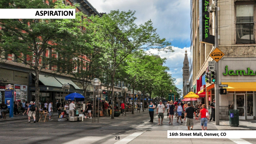
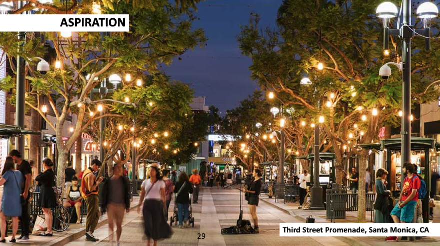
Planners say Fourth Street would form the "spine" of the downtown system, with Brush Square Park to the east and Republic Square Park to the west serving as bookends to a pedestrian-friendly corridor that's topped with a ground-level public space, akin to Denver's 16th Street Mall or Santa Monica's Third Street Promenade.
Austin Transit Partnership
Austin Transit Partnership
"We don't have a design yet. We'd have to work with [Austin's Transportation Department] and downtown stakeholders to see what the design would be," Mullan said. "But we think it could be really fantastic."
Public Input
Anyone can weigh in on the design plans during virtual community meetings in late July and early August. An online self-guided meeting will be available on ProjectConnect.com for a month starting July 27. An in-person open house is planned for July 31, from 10 a.m. to 2 p.m. at the Central Library.
"light" - Google News
July 17, 2021 at 01:47AM
https://ift.tt/3ihGOMu
Here's What Austin's Underground Light Rail Could Look Like - KUT
"light" - Google News
https://ift.tt/2Wm8QLw
https://ift.tt/2Stbv5k
Bagikan Berita Ini


0 Response to "Here's What Austin's Underground Light Rail Could Look Like - KUT"
Post a Comment