You know what they say... hindsight's 2020! Happy New Year, and what a way to ring in 2021! Our new year got off to a rather slippery start, with widespread freezing rain, sleet, and snow across the area.
Thankfully (as of about 8 PM Friday evening) the winter storm has ended. Roads still remain slick, however, and another brief round of snow is possible Saturday afternoon. Let's take a detailed look into what lies ahead.
Friday Night
The main focus of Friday night will be travel conditions. Even though the wintry precip has ended, area roads are still wet or slushy. As temperatures drop tonight, some of the water and slush will re-freeze into ice.
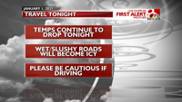
Salt becomes less and less effective the further below freezing we drop, and we're expecting lows in the lower 20s across mid-MO.
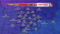
Additionally, all that ice and snow on the ground may create some patchy fog later on tonight. It shouldn't be too impactful, but keep in mind that fog can lead to ice buildup on objects and surfaces. You'll probably want the ice scraper for Saturday morning, and - once again - road conditions may be slick.
Saturday
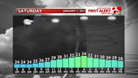
We'll wake up to cloudy skies and a bit of patchy fog to begin the first Saturday of 2021. Temperatures will be slow to rise, with highs only topping out in the lower 30s.
For the second half of the day, a small chunk of atmospheric energy will lift up into Missouri. This disturbance will be strong enough to produce some light snow. However, it doesn't have a lot of moisture to work with (today's winter storm used up most of it). As a result, we're only looking at patchy snow showers Saturday afternoon.
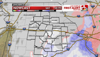
The better chances for snow will be south and east of Columbia, with the best odds near I-44. Accumulations will be light, with anywhere from a dusting to a half inch for most. Isolated totals up to 1 inch are possible in Miller, Maries, Osage, and Gasconade counties.
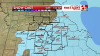
Any snow in mid-MO will shift east by late evening. This leaves us dry by Sunday morning.
Sunday & Beyond: a Change of Pattern
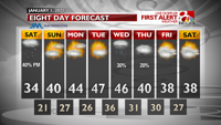
Sunshine will make a return to the area for Sunday. Combined with southerly winds, our highs should rise to near 40 for Sunday afternoon. That will lead to significant melting of snow and ice. Most of our roads will dry out, and the ice/snow will disappear from trees and bushes.
As we look ahead into the first full week of 2021, the mild pattern continues. We will be solidly into the 40s across the area by Monday, and highs for Tuesday and Wednesday will lift into the upper 40s.
A cold front is due into the region Wednesday afternoon, but given the warm temperatures, any precipitation that accompanies it will likely be in the form of rain.
Welcome to 2021, and have a great (and safe) night!
"light" - Google News
January 02, 2021 at 08:35AM
https://ift.tt/3n8B9Zg
The winter storm is over; light snow Saturday + warmer temps ahead - KOMU 8
"light" - Google News
https://ift.tt/2Wm8QLw
https://ift.tt/2Stbv5k
Bagikan Berita Ini


0 Response to "The winter storm is over; light snow Saturday + warmer temps ahead - KOMU 8"
Post a Comment